Cloud Burst in Himachal Pradesh 2025 – Causes, Effects & Heavy Rain
Published: 12 Oct 2025
Introduction
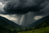
In 2025, Himachal Pradesh experienced a sudden cloud burst bringing heavy rainfall to its valleys and mountains. Places like Shimla, Mandi, Manali, and were affected by sudden storms. Streams turned into rivers within minutes, carrying mud, debris, and plants to lower valleys.
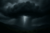
CloudBursts occurs naturally when clouds carrying large amounts of water release it rapidly. Mountains in Himachal trap clouds and when warm air from the plains meets cold mountain air pressure rises in the clouds. Once clouds cannot hold water heavy rainfall occurs suddenly.
Causes of the 2025 Cloud Burst
Warm air from Punjab and Haryana moved toward Himachal Pradesh. When this warm air met cold mountain air clouds formed quickly over Shimla, and Mandi. Dark clouds sudden winds, and drops in temperature warned locals of the upcoming heavy rain.
Mountains blocked cloud movement. Clouds stayed in one area causing water pressure to increase. When the limit was reached, rainfall occurred within minutes.
Impact on Valleys and Mountains
Shimla, Mandi, Kullu, Manali, and Kinnaur saw rapid water flow. Roads were blocked by mud and rocks. Gardens and small shops were submerged. Trees bent under heavy rain and soil erosion occurred across many areas.
Small farms were damaged.
Loose soil, rocks and plants were carried into lower valleys.
Streams created new paths and the landscape changed temporarily.
Effects on Wildlife
Birds moved to higher ground, and small animals fled flooded areas.
Forest paths became slippery and dangerous.
Weak trees and plants were washed away or damaged.
Ecosystems temporarily changed due to the heavy rainfall.
Local Experience
Residents described rainfall as intense and sudden. In Manali, shops were closed. Villages faced blockages due to mudslides. People moved to higher ground to stay safe. Tourists had to remain in shelters.
Environmental Impact
Soil erosion and landslides were significant. Rivers carried debris to the plains. Farmers waited for soil to dry before planting. Trees and small plants were damaged. Water created new channels in some areas.
Even after rainfall stopped, hills remained unstable. Minor landslides occurred days later. The environment slowly returned to normal but traces of the cloudbrust remained.
Recovery and Lessons Learned
Valleys and mountains gradually recovered. Rivers returned to usual paths. Soil stabilized and vegetation grew again. Locals observed cloud patterns wind direction and humidity for future warning signs.
The 2025 cloud burst reminded everyone that nature acts quickly. Respecting mountains and observing signs of sudden rainfall is essential for safety.
Conclusion
The cloudburst in Himachal Pradesh 2025 highlighted nature’s strength. Valleys & rivers and mountains experienced sudden heavy rainfall. Residents and tourists witnessed the power of water soil and weather combined. While valleys returned to calm the memory of the storm remains. Understanding mountain weather and observing natural signs are key lessons from this event.
FAQs
Q1. What is a Cloud Burst?
A Cloud burst is sudden heavy rainfall in a small area occurring when clouds release all trapped water.
Q2. Why does Cloud Burst happen in Himachal Pradesh?
Mountains trap clouds. Warm air from plains meets cold mountain air increasing cloud pressure and causing sudden rain.
Q3. Which areas were affected in 2025?
Shimla, Mandi, Kullu, Manali, and Kinnaur experienced heavy rainfall and water flow.
Q4. How long does a Cloud Burst last?
It can last from a few minutes to one hour, but its effects on soil, rivers, and vegetation continue for weeks.
Q5. What are the environmental effects?
Soil erosion, landslides, broken streams, washed-away plants, and changed river paths.
Q6. Can people prepare for Cloud Burst?
Observing dark clouds, sudden wind changes, and high humidity can help locals take shelter safely